
Save as printable pdf document | Download route gpx file (without waymarks, suitable for OS app).
Note : the estimated time below is calculated automatically according to Naismith's rule. A more realistic estimate is 2 hours 45 minutes.

Start Point: Coed Llwyncelyn car park. Grid ref. ST 202 854, What3Words: ///wisely.vibrate.kicks
Getting there from Cardiff:
by bus: Service 27 from Kingsway to Birchgrove near Waun y Groes Road. Cross A469 to Ffordd Mograig to catch service 86 to Lisvane Memorial Hall. From there you have a 3-kilometre walk going back along Heol y Delyn and then left along Rudry Road to the start point at Coed Llwyncelyn Car Park.
by car: out of Cardiff, past the castle on North Road, over the Gabalfa flyover, onto the A469 through Birchgrove. When you reach a roundabout go right into Ty-Glas Road, then bear left at the traffic lights continuing on Ty Glas Road. Then go right at the roundabout by the Church Inn onto Station Road and carry on through Llanishen Village onto Lisvane Road to Lisvane. Turn left into Church Road, then second right into Rudry Road. Go right then left to cross the new development road, then pass under the M4 and about 2 kilometres after you will see the forestry car park on your left.
Route Description:
First published 1997; revised and updated for 2022.
[1] Go through the barrier at the back of the car park and follow the track, ignoring two paths to the right, until it meets another track at right angles. Turn right onto this track gradually climbing, and where it starts to level out look for a stone marker post on the left. Take the path on the right opposite the post and follow it to, and go through, a waymarked gate. Pass to the left of a pylon, behind which, on a clear day, you have a view down to the Bristol Channel. Bear left to follow the field boundary on the left-hand side down to a stile into Coedcae wood. Over the stile and continue downhill almost to the valley floor where you meet another path crossing at right angles (there is a gate and stile on the left marking it). Turn right and follow this path upwards through the wood until it reaches a stile at the boundary of the wood and open fields. Cross into the field and go half left through the middle of a line of trees at a way marker post. Carry on in the same direction to go through a large gap in another line of trees. Then ahead to the right of a telegraph pole to a kissing gate in the field boundary.
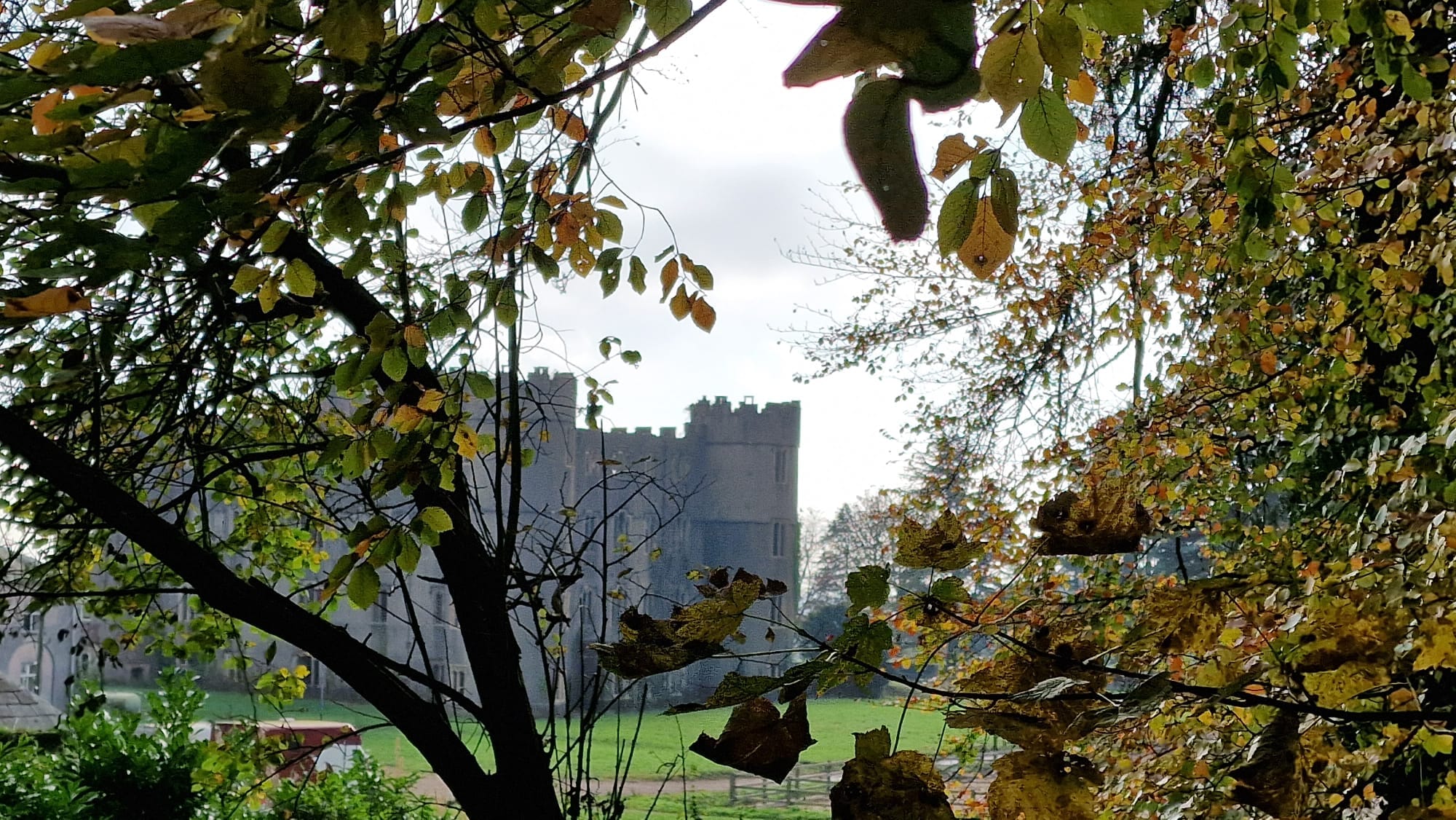
[2] Turn left onto the road, taking care, and shortly after the house you reach a road junction. Cross the road straight ahead to two parallel tracks and take the one on the left. This is part of the Rhymney Valley Ridgeway Footpath which you will be following all the way to Draethen. It takes you past a house and through a gate into a field. It then follows a stone wall, going through a second gate into the woods and then following a fence on the right. Ignore the first two gates and a barrier on the right, then at a clearing with a green shed, go over/through a stile/gate on your right to the track. Turn left and follow the track past a large house on your left. At the T junction, you will see a kissing gate opposite into Craig Ruperra woods, and an information board. Do not take the kissing gate but turn right and take the track to go towards Ruperra Castle and its grounds.
RUPERRA CASTLE: "splendidly direct and uncompromising" according to John Newman in "The Buildings of Wales; Glamorgan". The castle was built as the home of Sir Thomas Morgan around 1620, rebuilt 150 years later after having been burnt down and is now nothing but a ruined shell. It is a square, three-storied building built in a style harking back to mediaeval castles as can be seen in the round towers and battlements.
[3] About 24 metres after the start of a substantial wall on the right, turn left onto a signposted path between the trees and bushes. If you reach the end of the wall, you have gone too far. Take this path, up steps then up a gentle incline as it goes left. Where it levels out cross one path (which leads to the motte at the top of the ridge on your right, Craig Ruperra), and continue slightly downhill until you meet a track by a bench. Turn right onto the track. After about 200 metres the track forks. Take the left fork down through the wood, Coed Craig Ruperra, to Draethen, taking the second left (straight across) at a way marked crossroads. Eventually go through a gate at the boundary of the wood and an open field. Continue down the field to the right hand far corner where there is a stile at the back of the pub, The Hollybush, (currently closed down), which allows access via the pub forecourt to the Rudry-Draethen road.
[4] Turn sharp left and follow this road carefully as it has no pavements. Go past the outlying houses of the village where there is a green bridleway marker showing a track which crosses the road. Turn right and follow this concrete lane up between houses to the gate of the house ahead. Take the way marked path to the left and then right between a barn and the house. The path now begins to climb through Coed Cefn-Pwll Du. This is the steepest and longest ascent of the walk. Follow this path going right at the first fork, and straight on at the next junction. Where it begins to level off, after a narrow path crosses the track diagonally, it forks into 2 wide paths, take the left-hand path to an unmade road. Turn left onto this road and follow it for about 400 metres until it veers right and then, as it turns left, go straight ahead into a clearing with a Cambrian Way marker. Pass through a pedestrian entrance between large rocks to a tarmac road. Turn left and follow the road for another 800 metres, with views over the valley, until it reaches the Maenllwyd Inn at Rudry.
[5] Cross the road from the inn and go up the steps to the left of the Maenllwyd car park. Follow the path up 2 more steps and then to the right to go through a kissing gate. Turn right and then go left up some wooden steps to the right of a picnic area. Follow the path to a wide track and go right onto the ridge (Craig y Llan). You are now back on the Rhymney Valley Ridgeway Footpath. Keep on the ridge until 20 metres after a green barrier gate and before a pylon, and take the way marked path which comes up from the left. Follow this path down, with a steep drop and a handrail on the left, past old lime kilns and descend very steeply to Nant y Cwm. At the bottom turn right along the path, and after 10 metres take the path just past the stile on the left.
[6] The path goes through the wood and down to a footbridge over a stream. The footbridge is currently awaiting repair so you will need to ford the stream, then go through a kissing gate to a second footbridge to cross another stream. Turn left so that the stream is on your left and Coed Coesau-Whips on your right. As you approach a gate look to your right and you will see a stile which crosses the fence to another stile on the right into the corner of the wood. Take this stile and follow the path up through the wood with the open field on the left until you leave the wooded area and meet another path where the trees in front have been harvested (2022). Turn right on this path as it gradually descends to a T-junction, and then take the track left. Follow the track to a fork and go left, then follow the track, ignoring a left turn, to another fork, go left and back to the car park.
Ruperra Castle